

Description
Product Overview
Sportsman’s Connection Fishing Atlas is a comprehensive guide designed for anglers who demand precise geographic information and reliable navigation tools. The 7th edition print replica captures every major freshwater fishing region in the United States, presenting detailed topographic contours, water depth indicators, and seasonal fish activity charts. Each page is rendered from high‑resolution source maps, ensuring that the visual fidelity matches the original digital version while providing the tactile convenience of a physical book. The atlas measures 8.5 × 11 inches, offering a comfortable size for field reference, and its durable binding resists wear from frequent handling on boats, docks, or rugged terrain.
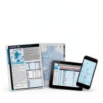
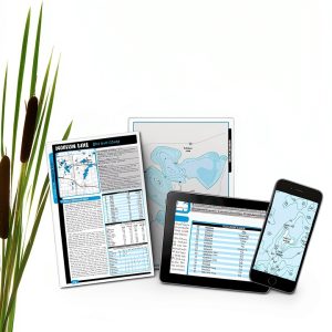
![[Product front view showing all components]](https://www.netnets.store/wp-content/uploads/2026/06/922a7f7d6dfc4ebba99ec4c2a546e0db.jpg)
The atlas is organized into regional chapters that correspond to major river basins, lake systems, and coastal estuaries, allowing users to quickly locate the area of interest without flipping through unrelated sections. Within each chapter, maps are annotated with key landmarks such as boat ramps, public access points, and wildlife refuges, providing a holistic view of the surrounding environment. In addition to geographic data, the guide includes practical tips on local regulations, recommended gear, and seasonal patterns that influence fish behavior. This blend of cartographic precision and on‑the‑ground advice makes the atlas an indispensable companion for weekend trips, multi‑day expeditions, and competitive fishing events.
Printed on high‑quality, acid‑free paper, the Fishing Atlas resists moisture absorption and fading, ensuring that critical information remains legible even after exposure to splashes or sunlight. The binding incorporates reinforced stitching along the spine, a feature typically reserved for premium field guides, which prevents pages from loosening during extended use. Color‑coded legends simplify the interpretation of depth contours, vegetation density, and fish habitat zones, while a supplemental index at the back of the book provides alphabetical access to over 1,200 named fishing sites. For anglers who prefer digital tools, the print replica mirrors the layout of the Kindle version, allowing seamless cross‑reference between devices and the physical copy.
The atlas serves a broad audience, from novice anglers learning the basics of freshwater fishing to seasoned professionals seeking competitive edges in tournament settings. Its clear, jargon‑free language makes it accessible to readers with varying levels of experience, while the depth of data satisfies the analytical needs of those who track catch statistics and environmental variables. By consolidating a wealth of information into a single, portable volume, the guide eliminates the need to carry multiple charts, notebooks, or electronic devices, streamlining preparation and reducing the risk of equipment failure in remote locations. Whether you are planning a sunrise bass run on a secluded lake or a late‑season trout pursuit in a mountain stream, the Fishing Atlas equips you with the knowledge to make informed decisions and increase your success rate on the water.
The atlas employs a consistent 1:250,000 scale across all regional maps, allowing anglers to gauge distances and travel times with confidence. Symbol legends are presented on each page, using intuitive icons for boat launches, fishing piers, and wildlife observation points, which reduces the learning curve for new users. An extensive alphabetical index at the back of the book lists over 1,200 named fishing sites, each cross‑referenced to the appropriate map page, enabling rapid lookup without scanning entire chapters. Additionally, the guide includes a concise glossary of common fishing terms and measurement conversions, supporting readers who may be unfamiliar with regional terminology or metric units.
Beyond the printed pages, Sportsman’s Connection provides an optional online companion portal where owners can download supplemental PDF updates that reflect recent changes in waterway access or fish stocking programs. This hybrid approach ensures that the physical atlas remains a living document, capable of staying current without requiring a complete reprint. Users who subscribe to the portal receive notifications about seasonal advisories, new public launch sites, and conservation initiatives, enhancing the value of the original purchase. The seamless integration of print and digital resources exemplifies the brand’s commitment to delivering comprehensive, up‑to‑date information for the modern angler.
Sportsman’s Connection emphasizes environmental stewardship by incorporating conservation guidelines directly into the atlas. Each regional chapter includes notes on protected habitats, catch‑and‑release best practices, and local regulations that promote sustainable fishing. The guide encourages anglers to respect seasonal closures and to adopt low‑impact techniques that preserve water quality and fish populations for future generations. By aligning recreational pursuits with ecological responsibility, the atlas serves not only as a tool for personal success but also as a catalyst for preserving the natural resources that make freshwater fishing possible.
Usage
Designed for field conditions, the Fishing Atlas fits comfortably in a standard backpack or tackle box, allowing anglers to consult the maps at the water’s edge without sacrificing other essential gear. The lightweight paper stock adds minimal bulk, while the sturdy cover protects the pages from accidental spills and abrasion. During a typical day on the river, a fisherman can flip to the relevant river basin chapter, identify the most productive stretches based on depth and habitat markers, and pinpoint nearby access points that accommodate small watercraft. This rapid reference capability reduces time spent planning on the shore and maximizes the hours available for casting and retrieving.
In colder climates or during early‑morning outings, the atlas’s clear typography and high‑contrast legends remain legible even in low‑light conditions, especially when paired with a headlamp or portable LED light. The inclusion of seasonal fish activity charts enables anglers to adjust their tactics according to spawning periods, water temperature fluctuations, and migratory patterns. For example, a user targeting walleye in the Great Lakes region can consult the spring chart to locate spawning tributaries, then use the depth contours to select optimal depths for bait presentation. This strategic approach, supported by the atlas’s data, often leads to higher catch rates and more efficient use of limited fishing time.
For anglers who prefer early‑morning or night fishing, the atlas’s high‑contrast color scheme and bold line work remain readable under artificial lighting. Pairing the book with a compact headlamp or a waterproof LED lantern allows users to consult depth contours and access points without compromising safety. The guide also highlights nocturnal fish behavior patterns, indicating species that are most active after sunset and suggesting appropriate lure selections. By providing this night‑time intelligence, the atlas helps anglers extend their productive hours beyond daylight, making the most of limited fishing windows in regions with short summer seasons.
Group outings and instructional workshops benefit from the atlas’s clear layout, which allows an instructor to point out key features while the entire class follows along on a shared copy. The printed format eliminates the need for each participant to carry a separate device, fostering collaboration and discussion about optimal fishing spots. Additionally, the atlas includes a set of suggested practice drills, such as mapping a target area and recording observed fish activity, which can be used to teach beginners the fundamentals of habitat assessment. This educational focus reinforces the atlas’s role as both a reference tool and a teaching aid for clubs, camps, and guided trips.
Planning a multi‑day fishing expedition becomes more efficient with the atlas’s integrated itinerary templates, which allow anglers to outline daily routes, target species, and required gear. By marking preferred launch sites and anticipated fishing hotspots on the maps, users can visualize travel distances and estimate fuel consumption, reducing unexpected detours. The guide also suggests complementary activities such as wildlife observation and campsite selection, enabling a balanced outdoor experience. This comprehensive planning capability helps anglers maximize their time on the water while minimizing logistical challenges associated with remote locations.
Why Choose Us
Sportsman’s Connection has built a reputation for delivering authoritative outdoor publications that combine rigorous research with practical field experience. The Fishing Atlas benefits from a team of seasoned anglers, cartographers, and wildlife biologists who collaborate to verify each data point, ensuring that the information reflects current conditions and regional nuances. This commitment to accuracy distinguishes the atlas from generic map compilations that may overlook local regulations or recent habitat changes. Customers can trust that the guide’s recommendations are grounded in real‑world testing, providing a reliable foundation for planning successful fishing outings.
In addition to the high‑quality content, Sportsman’s Connection offers responsive customer support and a satisfaction guarantee that underscores their confidence in the product. Buyers who encounter any issues with the atlas—such as missing pages, printing errors, or unclear symbols—can contact the support team for prompt resolution, including replacement copies or refunds when appropriate. This after‑sales service reflects a customer‑centric philosophy that values long‑term relationships over one‑time transactions. By choosing this atlas, anglers not only receive a superior reference tool but also gain a trusted partner dedicated to enhancing their outdoor experiences.
The production process adheres to environmentally responsible standards, using recycled paper and soy‑based inks that reduce the ecological footprint of the printed atlas. Sportsman’s Connection partners with conservation organizations to support habitat restoration projects, and a portion of each sale is allocated to these initiatives. This commitment to sustainability resonates with anglers who value stewardship of the waterways they enjoy. By purchasing the Fishing Atlas, customers contribute to ongoing conservation efforts while receiving a high‑quality reference that aligns with their ethical values.
Key Features
- Detailed, up-to-date maps covering all major U.S. freshwater fishing regions.
- High-resolution print replica mirrors the Kindle version for consistency.
- Durable, water-resistant binding and acid-free paper for field longevity.
- Seasonal fish activity charts and access point markers for strategic planning.
- Dedicated customer support with replacement or refund options.
FAQ
What areas does the Fishing Atlas cover?
The atlas includes every major freshwater fishing region across the United States, from the Great Lakes and Mississippi River basin to coastal estuaries and mountain streams. Each regional chapter provides detailed topographic maps, depth contours, and access point information, ensuring comprehensive coverage for anglers traveling nationwide.
Is the atlas suitable for use in wet conditions?
Yes. The atlas is printed on water‑resistant, acid‑free paper and features a reinforced stitched binding that protects the pages from moisture and wear. Its high‑contrast legends remain legible even when the pages are slightly damp, and the cover is designed to shield the interior from splashes and rain.
How can I get assistance if I receive a defective copy?
If you receive a copy with missing pages, printing errors, or unclear symbols, contact Sportsman’s Connection customer support. Provide your order details and a description of the issue, and the team will arrange a prompt replacement or issue a refund according to their satisfaction guarantee policy.
Overall, the Sportsman’s Connection Fishing Atlas combines precise cartography, practical guidance, and durable construction to empower anglers of all skill levels to explore and succeed on the water.


Reviews
There are no reviews yet.